Riding at Horsetooth Mtn Park
Horsetooth Mountain Park is a popular, multi-use open space area. It is a Larimer County Park. If you ride into the park there is no fee, but parking there costs $5/day or $50 for a season pass. The parking area is just off the lower-left corner of the map. To get there, take County Road 38E West out of town, toward Masonville. It takes about 15 minutes from campus by car, perhaps an hour by bike. Expect to see hikers, equestrians, and cyclists using the Park. Please, if you intend to cycle at Horsetooth Mountain Park (or anywhere else for that matter), be courteous to other trail users. Let's try to avoid the conflicts that lead to trail closure, which offroad cyclists are currently dealing with in Colorado's Jefferson County. It really doesn't take much of an effort to avoid being rude, and it will save lots of places to ride for all of us in the future.
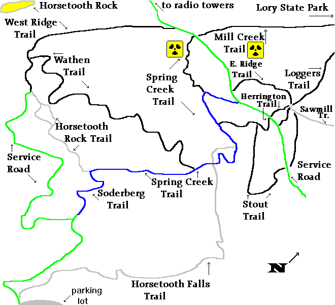
The major theme of cycling at Horsetooth Mountain is STEEP-ness. The sub-theme is TECHNICAL. I personally enjoy climbs that I can make without having to stop. That sort of climb is the exception at Horsetooth. Most of the singletrack trails are very difficult to climb, at least in places. My advice for people who enjoy both the climbs and the descents is; find the ways up that are climbable. Those are 1) the service roads 2) the sections of the Spring Creek Trail that are marked blue and 3) to a certain extent the East Ridge Trail. Lots of the trails that are fun to descend are a pain in the posterior to climb. Plan ahead to avoid climbing the unclimbable (also known as "pushing your bike").
My map has roughly followed the color-key system used by downhill ski areas. Green = easiest, Blue = harder, Black = expert. The trails that are drawn in gray are trails that are either prohibited for cyclists, or are otherwise not good cycling trails. The places marked with the Hazardous Waste symbol are life-threatening for cyclists. Ride at your own risk (as always). See disclaimer. The map is an imagemap, so you can see ride descriptions for individual sections by clicking on them.
Check out some 24-bit jpeg photos of Horsetooth Mountain Park (134 K).